Julian explores the autumnal glory of 'the Garden of the Inn'

Julian Barkway
Iam what can best be described as an enthusiastic amateur photographer. I try not to follow fashion or trends and I’m never happier than shooting with my 5x4 camera on good old sheet film. The intimate landscape is what interests me which is, perhaps, surprising given that I have been based in Switzerland for a number of years. My favoured habitat is the bottom of a rocky gorge but I do occasionally emerge to shoot the bigger vista. And I do occasionally shoot digital - but shhh, don’t tell anyone! website
One of the joys of living in Switzerland, as I have done for the past fourteen years, is the annual display of colour that marks this time of year. From the vineyards scattered along the northern side of Lake Geneva to the beech forests of the Jura and from the wooded hills of Ticino, replete with sweet chestnut, to the larch-covered mountainsides of Graubünden, Switzerland is a blaze of intense yellows, reds and ochres from mid-October up until winter's icy fingers start to reassert their annual hold over the high Alpine meadows.
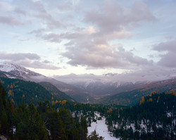
Arguably, the one region where this most transitory of seasons reaches its highest expression is Engadine, surrounded by mountains and tucked away in the south-east of the country. Its name is taken from 'Engiadina', meaning 'the Garden of the Inn' in the local Rhaeto-Romansch language and this is an apt description. Bisecting and defining an evocative landscape, the river Inn rises above the Upper Engadine village of Maloja at an altitude of some 2600m, tumbling quickly down into a broad valley where it pauses for a while in the serenely beautiful lakes of Sils and Silvaplana. Passing swanky St. Moritz, it flows into the steeper and narrower valley of the less well-known Lower Engadine then on past charming and evocatively-named villages such as Zuoz, Tarasp and Ramosch, finally taking its leave of Switzerland near the Tyrolean town of Nauders. This is a richly forested and mostly unspoilt area where glaciers, castles, quaint villages, wild rivers and tranquil lakes all jostle for the photographer's attention. Towards the end of October 2013, I spent a few days exploring the length of the valley, along with a couple of side-valleys, and the photographs which accompany this article were all made during this visit.
I approached Engadine from the west over the dramatic Flüela Pass, resplendent under a light covering of early snow, and immediately headed to the centrally-located town of Zernez to get my bearings. It is here that the river Fuorn joins forces with the Inn and it is near this confluence that Switzerland's first (and so far only) national park is located. Exploring this tract of highly protected Alpine landscape was one of the main aims of the trip so I started by driving the one road that crosses the park. The Pass dal Fuorn also happens to be the only direct link between the remote Val Mustair and the rest of Switzerland and is therefore a vital route for the inhabitants of this isolated valley. In addition to providing some useful vantage points from which to make scenic images, this road forms the start of several of the park's designated hiking paths.


