A Case Study - Glen Etive and Ballachulish

Tim Parkin
Amateur Photographer who plays with big cameras and film when in between digital photographs.
Last year we had a spate of planning applications in the Glen Etive/Rannoch Moor area. Firstly the King’s House hotel was sold to the Black Corrie’s Estate and, with a lease to Crieff Hydro negotiated, a rebuild of the newer part of the King's House was proposed. The design was disliked by most in the extended community but still, the planning officers waved it through. With my eye already on planning applications in the area, I also noticed an application for run-of-river hydro developments in the Glen Etive area. This was not just a single small weir in the commercial forestry area of the Glen, which would have been annoying but acceptable, but the damming of every single significant water flow into the river Etive.
I linked up with a group of people online, a ragtag bunch of writers, walkers, environmentalists (i.e. a bunch of normal people who really care about the landscape) who were brilliant to work with and with whom we developed a plan of action to try to protest these applications.
One of our first priorities was the development of a Facebook page and website to raise awareness of the issues and try to inform the public of what they could do to submit their own objections. I should point out here that we weren't being NIMBYs here, we reluctantly agreed that half of the schemes in the forestry commission areas were acceptable but those within the multiply designated wild land areas were not.
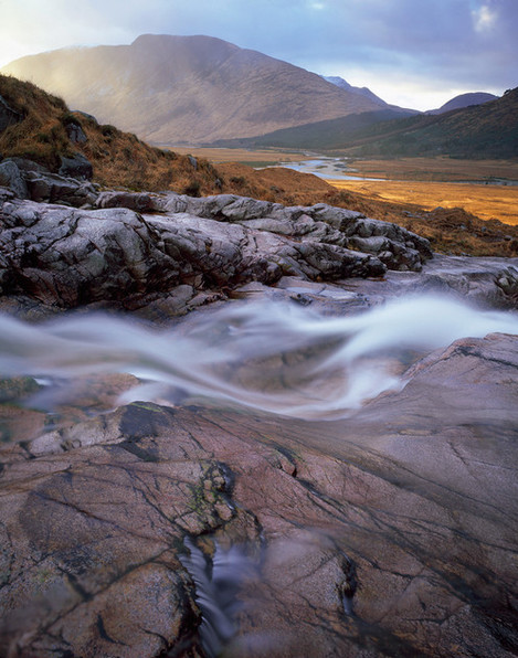
It fell on myself and David Lintern to do most of this work on the website as I have the IT/design experience and David is excellent at writing. It quickly became apparent that one of the primary resources to raise initial awareness of what might be lost was inspiring photography. Fortunately, one part of the Glen has been popular with a few photographers for a while and so I was able to recruit a few photographers to share their photographs (see the website for details). Big thanks to David Ward, Colin Prior, Michael Stirling-Aird.
But this didn’t cover all of the tributaries and so I spent a few days wandering up and down the three rivers on the wild status land side of the Glen (the North side) in order to collect both video and drone footage for use on the website. Here is an example of the drone footage we used.
Because of the website and Facebook page, we managed to raise a huge amount of support and had petitions with over 10,000 signatures which we were able to supply to the planning officers as well as drone footage of the most at-risk river locations. We also managed to get an interview on the BBC news (which you can see here).
We were also able to create ‘simulations’ of how and where the weirs and pipes would go and the visual impact of them. They're very amateur ones but they were done in a hurry - better something rough and ready that shows clearly where things will land than just an abstract technical drawing.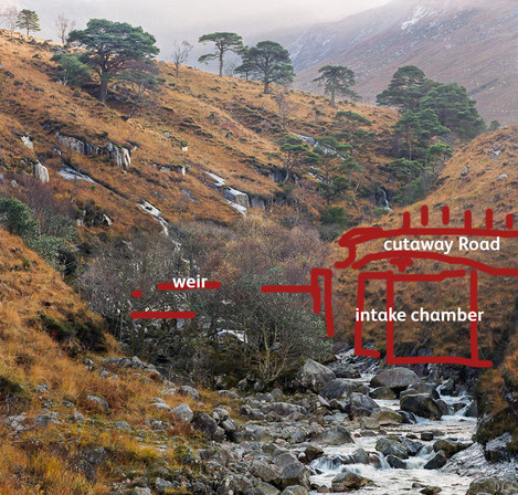
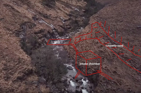
Sadly, on the first pass through the planning system, it was approved on the basis of community support (despite the fact that all of the six people in the community are employed by the developer in some way).
One of our local councillors managed to get enough support for a full hearing at the Highland Council in Inverness and our website and drone footage was used to support our objections. Again though, the planning was approved and so we thought that was the end of things.
However, the action continues and as developments start to happen, the photography will be used as a reference for the location before development as well as recording any out of 'planning' procedures.
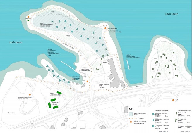
Another proposed planning application appeared just a couple of months later for 54 holiday homes on the peninsula outside Ballachulish, opposite Eilean Munde (the Isle of the Dead).
Although the proposal is withdrawn at the moment, I will be ensuring the area is well represented photographically in preparation for a possible planning objection.
Using your photography to help support objection campaigns
Despite being unsuccessful at stopping the Glen Etive application, it made me realise just how important photography can be in raising awareness of the constant encroaching of our landscape. Although I live in a fairly spectacular part of the country, the use of photography to show the beauty of less spectacular areas can be a major tool in ensuring the unwarranted development of publicly accessible open areas, parks and countryside.
So how can you go about trying to help in your local area?
The easiest way to do this is to subscribe to your local paper and keep an eye out for campaigns. Alternatively, contact your local councillor or MP. They will have had various issues raised to them and a quick request via email and you will probably be put in touch with one or two local groups that campaign on such matters.
Once you’ve found such a group, ask them what they might need in the short term. In the longer term, the following types of photographs will be useful
- Showcase images to be used to show the beauty of a place
- Reportage images of ‘action’ happening around a place
- Ongoing rephotography campaigns to show changes in an area
Showcase Images
These are the bread and butter of most landscape photographers work but make sure you capture images that show the extent of the area in question, not just details.
Reportage
You might not be a reportage photographer but you’ll still probably have more skills and understanding of photography in general than the people campaigning or of people enjoying the space. Don’t underestimate how useful environmental portraits can be too. I haven't taken any of these but David Lintern, who worked with me on the website took a few good ones and here's another of kayakers contributed by Paul Crossan.
Rephotography Campaigns
Showing the way a landscape changes naturally and by the hand of man will help to demonstrate what is happening in a way that the written word can struggle with. This may be river bank erosion (in Ballachulish we have an issue where the local water authority changes the flow of the river slightly and in so doing changed the water so it starts to destroy a local path), changing water levels (showing how floods may cause problems in developments), etc.
Tell us How You've worked or Campaigns that you might help with
If you’ve helped in campaigns like this in the past, we’d love to hear from you. I’m no expert and only got involved in the Glen Etive and Ballachulish campaigns when I realised if it wasn’t me, there would be nobody else.

